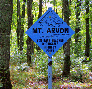
Mount Arvon – A Must See
Part of the Huron Mountains, Mount Arvon is Michigan’s highest point. Rising 1,979 feet above sea level and fairly accessible by many vehicles, the summit of Mount Arvon is definitely worth checking out.
A Brief Summary of Mount Arvon
You drive through L’Anse, take a trip down Skanee Road, then turn onto what shortly becomes a gravel road. Eleven curvy miles later you reach the top of Mount Arvon.
There’s a sign noting that you are in fact at the top of Michigan’s Highest Point. There’s also a picnic table, a fire pit and a mail box.
Oh, and there’s a pretty awesome view.
There didn’t used to be a view. But now a few trees have been cleared and on a clear day you’ve got a beautiful view of Lake Superior and the Huron Islands.
And about that mailbox…
The mailbox contains a book for you to sign your name, where you’re from and when you visited. It’s pretty cool to flip back a few pages and see all the different people from all over the place that have been here. There’s even a group of people called the High Pointers Club that are all about reaching the highest point in each state. If you see something like “HP 22” next to someone’s name, now you know why. (For the record, this was HP #1 for me!)
Mount Arvon: Not Really a Mountain
Apparently geologists get to decide what is a mountain and what is not a mountain. And from what I’ve heard, geologists say that a mountain is anything over 2,000 feet above sea level. Of course, this leaves poor Mount Arvon a measly 21 feet short of true “mountain” status.
Well Mount Arvon, you’re still a mountain to me.

MT. ARVON Mt. Arvon is Michigan’s highest point standing at 1,979.238 feet above sea level. It is located in the rugged backwoods of Michigan’s Upper Peninsula in beautiful Baraga County, approx 27 driving miles from L‘Anse, Michigan.
Getting to Mt. Arvon is no easy feat if you don’t know your way around. Currently, blue diamond shaped signs (about every mile) mark the route to Mt. Arvon. PRIMARY ROUTE Approach: From the intersection of US Hwy 41 and Broad Street immediately South of L’Anse, proceed north into L’Anse on Broad Street for 0.7 miles to Main Street. Turn right on Main Street which will become the Skanee Road, and continue 16.1 miles to Church Road (formerly Roland Lake Road) on the right, where the Zion Lutheran Church is on the SE corner. Turn right on Church Road and proceed 2.9 miles to Ravine River Road to Roland Lake (see map at right for a detailed description). Turn right on Ravine River Road and continue 6.1 miles to T-intersection. Turn right and continue 0.9 miles to the trail on the right which actually is an old logging road. There are many less well-developed roads in the Ravine River Road area. Please follow the blue signs that mark the way to the top. Unless indicated below, stay on the obvious “main track” as you proceed along Ravine River Road. The route on Ravine River Road is as follows: (at this point reset the odometer). At 0.7 miles, fork, go straight; 1.8 miles, pass through gravel pit; 2.0 miles, leave gravel pit at a fork, go straight; 3.0 miles, fork, bear left; 3.4 miles, fork, bear right; 4.0 miles, 4.5 miles and 4.7 miles, forks go straight; 6.1 miles. T-intersection, main road goes left, turn right, 6.3 miles fork, go left; 6.4 miles, steep incline at the point, fork, go right; 6.8 miles, fork, go right 7.2 miles go to right. At this point there is a parking lot and there is an approximately 1/4 mile walk to the summit. A USGS benchmark and mailbox containing a register will be found on the summit. Return down the mountain the same way.
http://www.michigan.org/property/mount-arvon/

Recent Comments